Peak District Walks - Mam Tor


A favourite walk of mine

Here is a really popular viewpoint, on the hike up to the top of Mam Tor. This image shows the winding road into the village of Edale and in the far distance the Kinder Plateau and the start of the Pennine Way, which forms part of the UK’s trail network.
It is a impressive sight. Good to travel down, but harder to travel up. Especially if you decide to give it a go on your bike.
I wanted to focus a little more on one of my favourite walks in the Peak District, a walk that focuses on the well-known destination of Mam Tor.
Mam Tor is an excellent location to visit and one of those exciting places that not only holds a special place in my heart, but also in the hearts of others. Especially, those individuals who enjoy walking in the glorious Peak District.
It helps form a popular focal point for anyone visiting this particular area, of the Dark Peak and the more extensive Peak District National Park beyond.
Also, it is an area of geographically and geological significance that lies on the border of two major rock types, Limestone and Gritstone. These rock types help to shape the appearance and structure of the surrounding landscape.
It has some of the Peak District’s most beautiful walks and many different types of outdoor pursuits and adventure sports for visitors to enjoy.
The area has so many walks to choose from

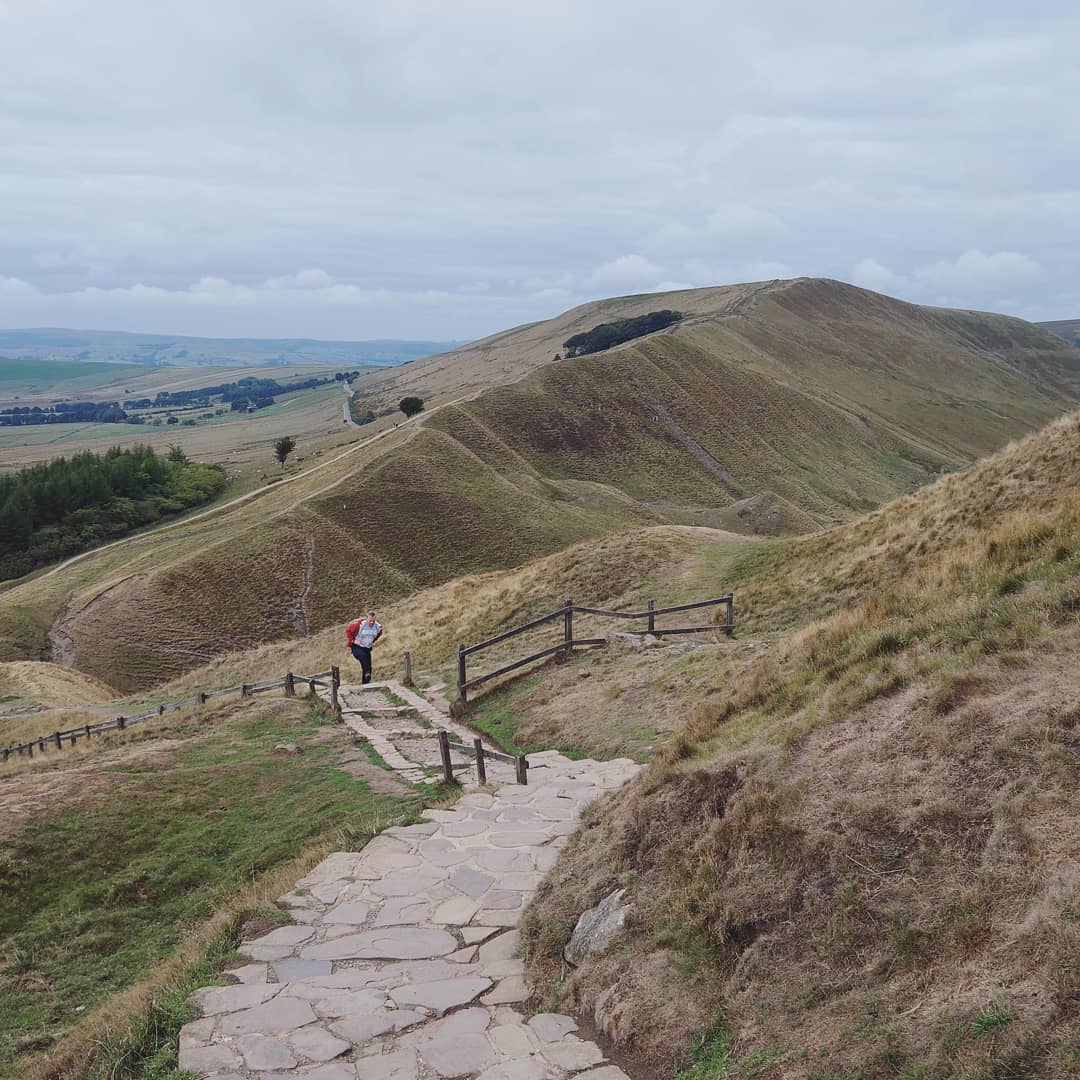
On the way up to the summit of Mam Tor.
It is a steady and well paved climb. On the left of the shot are the remains of an Iron Age hill fort and on the right, a steep drop and impressive views of the countryside.
There are many different walks to choose from, with each one varying in distance and degree of difficulty.
It is a region that offers some of the most exquisite landscapes and some of the most memorable views. Making it a mecca for walkers of all ages and abilities, mountain bikers and landscape photographers, hoping to capture a little memento from this picture perfect area of the UK.
I know the area particularly well, as I have used it for hiking, for many years. For over seven years, I was lucky enough to lead guided walks here. Regularly walking up Mam Tor and then onward into the nearby valleys of Hope and Edale.
The guiding walks were all part of my own initiative. I would design and run bespoke outdoor residential trips. That not only focused on the main principles of outdoor education, but also focused on how we could use the outdoor environment and its unique surroundings, as a valuable learning tool.
It was always an exciting and exhilarating experience, and I continually feel incredibly proud of myself for designing and implementing such activities. Always bringing meaningful and purposeful experiences for other individuals to simply get outside and enjoy.
Experiences that build upon interests, knowledge and enthusiasm. Over the years, I have introduced many individuals to this unique area and in turn, they have learnt more about their geographical surroundings, and carried out tasks/activities that further encourage opportunities to embrace challenge and experience some of the most dramatic scenery for miles around.
This walk starts in the village of Castleton
On this particular day, my walk starts in the village of Castleton. In the centre of the village, at the car park located next to the local tourist information centre. I always find this is a convenient spot and the ideal location to then start your walk from. Once parked up and a days parking paid for, I generally take a quick visit to the nearby shop for necessary food supplies, as the hiking trail can often vary in length and can be reasonably challenging in parts.
Experience tells me to make sure you are well prepared, as not only can the weather frequently change here. Making it a dangerous environment to be in, but your energy levels can diminish quickly, in a short space of time. Often leaving you prone to tiredness and lethargy, always when you least expect it.
Once stocked up, I walked through the village and pass by the old Youth Hostel and onward towards the small village green, with the rest of this route eventually leading me towards the impressive starting point of Cavedale.
Unforgettable Cavedale
Geographically, Cavedale must rank highly on places to visit, for any Geographer or Geologist, and if you have not ever been here, then I must say that it is well worth the detour from another walk or purposeful visit. You won’t regret it, as it is undoubtedly a spectacular location for you to revel in one of the UK’s most beautiful natural landscapes.
The path leads from the very top of Mam Tor and eventually weaves its way forwards to Rushup Edge, in the distance.
At the start of the dale, the valley sides are almost perpendicular and reach over 50 metres in height. The dale path begins to rise gently, soon after leaving the village and this then becomes steeper and more rugged underfoot.
It culminates with a perfect viewpoint down into the dale, which also takes in the spectacular Peveril Castle, perched high on the top.
After admiring the impressive views, the dale then rises once more and soon swings west and then begins to level out with the beginning of some more gentle gradients. These then become just a shallow depression, as they start to peter out onto the open pastures close to the crossroad and paths at the very top.
Cave Dale is a spectacular sight (from any angle) and was initially formed by torrents of glacial melt water, that began carving a deep narrow valley into the surrounding soluble limestone. The river then found a route underground leaving a dry valley with several caverns underneath, some of which are still visible today.
As time passed the caverns below Cave Dale collapsed making the valley even more profound and more gorge-like at the northern end. With the Castleton entrance to Cave Dale having a narrow natural arch as recently as 200 years ago. This arch was a relic of the roof collapse. The lower slopes of the dale have large amounts of scree deposits, which is formed by frost on the higher limestone cliffs having caused the rock to shatter and then fall. Halfway up the valley is an impressive outcrop of basaltic lava with a few small columns protruding out of the surface.
For wanderers, a bridleway runs the entire length of the dale, and this forms part of the Limestone Way footpath which extends some 80 kilometres from the village of Castleton to Rocester, in the east of Staffordshire. Access to Cave Dale is through a narrow rocky opening almost from the centre of Castleton, with Peveril Castle being located high up on the nearly vertical western slopes.
It is an impressive fortification, as the Normans chose this site, as a perfect defensive position, mainly due to the steep sides of Cave Dale giving a natural defence, allowing for ultimate protection against any potential enemy invaders.Where the trails cross
At the very top of the relatively steep climb is a footpath marker, that marks the meeting point of various paths. Here you have the option to follow multiple routes. On this particular walk, I choose to turn right and make my way across the levelled pastures that roll out towards the foot of Mam Tor.
This part of the walk is inviting, and I find the the views are pretty sensational. Allowing you to see many miles in both a westerly and easterly direction. I love these viewing points, as they not only make for good breathing and head space, but also a good photograph.
From this point you can follow the path and then weave your way towards the foot of Mam Tor. It dominates the landscape right in front of you and looks a very impressive and inviting sight.
The approach towards Mam Tor and the Summit
The fields roll on, and soon after crossing the main road, you will eventually reach the wooden stile that leads to the path and climb up to the summit of Mam Tor. At this point, the hill is pretty steep and the route soon begins to split into two sections.
The first section is a rugged path up the hillside. It is important to be careful here as the slopes can often be slippery and underfoot the surfaces can be somewhat uneven. Good shoes are a must so, be careful where you tread.
Once you have tackled the reasonably steep last hill you eventually reach the gate that marks the start of the cobbled path and the final climb up to the summit of Mam Tor. This point is a great place to grab your breath or take in a drink and snack. It is relatively sheltered here as the cutting, through which the road goes, acts as a natural barrier from the wind.

The views from the top are really spectacular and well worth the effort.
Here you will see a wonderful 360 degree view of the landscape all around. Something that is inviting and not to be missed.
When you set off on this section of the walk, be sure to take your camera with you and be prepared to make a stop. Allow yourself to admire your surroundings and take in the beautiful views.
In front of you, the valley of Edale eventually begins to appear, and the imposing Rushup Edge starts to show itself a little further behind you. To the right, the views are plentiful, as they stretch out into the valley below. Displaying a picturesque view of the villages of Castleton and Hope, far in the distance.
The climb to the top is soon done and the trig point (marker) soon appears in front of you. It is always satisfying to see, and once at the very top, it is well worth taking the time to enjoy some of the most exceptional views this region has to offer.
I personally would say it is one of the finest 360-degree views you'll find anywhere in the UK.
The Great Ridge
After reaching the summit, you can then spend the rest of the walk meandering along the ‘Great Ridge’ and travel towards other destinations like Hollins Cross, Back Tor, Lose Hill and other routes into Edale or the village of Hope.
The views from the ridge are pretty impressive too and begin to stretch out for miles all around. Along the Great Ridge you will get a great sense of scale and have many opportunities to simply admire just how beautiful the Peak District actually is.
On this particular day, I walked the ridge as far as Lose Hill and then into the village of Hope, where I decided to have a cafe stop and bite to eat, before making my way back to the car park.
So, where is Mam Tor located?
Most walkers, adventurers and sightseers generally head towards the village of Castleton, where they can begin and end their walks.
Castleton is easily accessible by car. With good links to the cities of Manchester in the West and Sheffield in the East.
Within the area there are many different underground caverns to be explored, which have been hollowed out by water eating away at the limestone rocks found below.
All these locations are well worth a visit and I shall provide the links below.
Further Links
In Summary
Whenever I'm back home in the UK, I do love coming back to this area and enjoy walking in this beautiful landscape. This popular destination never fails and in all types of weather it always provides a really enjoyable day out.
Of course, this is only a snapshot of just one walk here. There are many other to choose from and of course many other suitable locations to be discovered or rediscovered.
If you are visiting this area, be sure to take your camera with you and allow enough time to immerse yourself in the glorious Peak District.
Thanks for reading!
Adventure Calling

